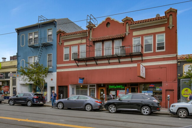
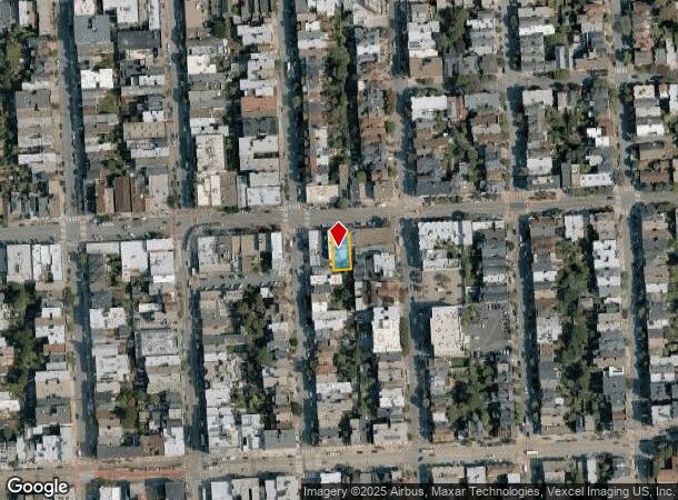
Property Record
635 Irving St, San Francisco, CA 94122

NEARBY LISTINGS FOR SALE OR LEASE
Property Detail
635 Irving St
San Francisco-Redwood City-South San Francisco, CA
Outside Land
1762-045
San Francisco
Retailwithmorethanonenonretailuse
California
2024
45
2025
0.12 AC
030202
West of Van Ness
7,388 SF
San Francisco
DEMOGRAPHICS near 635 Irving St
1 Mile
3 Mile
5 Mile
2024 Total Population
49,167
445,240
824,720
2029 Population
45,632
412,097
763,179
Pop Growth 2024-2029
(7.19%)
(7.44%)
(7.46%)
Average Age
42
43
42
2024 Total Households
20,589
192,784
346,470
HH Growth 2024-2029
(7.75%)
(7.88%)
(7.80%)
Median Household Inc
$147,617
$140,630
$125,142
Avg Household Size
2.30
2.20
2.20
2024 Avg HH Vehicles
1.00
1.00
1.00
Median Home Value
$1,124,220
$1,115,147
$1,096,503
Median Year Built
1947
1948
1949
Nearby Places
Map Layers
Map Styles
 Street
 Aerial
- Restaurants
- Banks
- Shops
- Fitness
- Groceries
PUBLIC TRANSPORTATION
COMMUTER RAIL
San Francisco 4th & King (Caltrain - Caltrain (Caltrain))
DRIVE
WALK
Distance
San Francisco 4th & King (Caltrain - Caltrain (Caltrain))
11 min
4.5 mi
DRIVE
WALK
Distance
11 min
4.5 mi
AIRPORT
San Francisco International
DRIVE
WALK
Distance
San Francisco International
25 min
14.5 mi
Metro Oakland International
DRIVE
WALK
Distance
Metro Oakland International
39 min
23.1 mi
Norman Y Mineta San Jose International
DRIVE
WALK
Distance
Norman Y Mineta San Jose International
61 min
46.6 mi
Freight Ports
Port of San Francisco
DRIVE
WALK
Distance
Port of San Francisco
15 min
6.1 mi
SALE & LEASE HISTORY
LISTING DATE
SALE/LEASE

Jul 27, 2020
For Sale
Nearby Properties
Address
Land Use
TOTAL SIZE
Lot Size
Zoning
Address
Land Use
TOTAL SIZE
Lot Size
Zoning
1,015,000 SF
2.43 AC
RC4
Address
Land Use
TOTAL SIZE
Lot Size
Zoning
248,303 SF
4.35 AC
Address
Land Use
TOTAL SIZE
Lot Size
Zoning
1.52 AC
C3G
Address
Land Use
TOTAL SIZE
Lot Size
Zoning
24.37 AC
Address
Land Use
TOTAL SIZE
Lot Size
Zoning
2.93 AC
Address
Land Use
TOTAL SIZE
Lot Size
Zoning
342,727 SF
1.36 AC
C3G
Address
Land Use
TOTAL SIZE
Lot Size
Zoning
411,904 SF
21.74 AC
C2
Address
Land Use
TOTAL SIZE
Lot Size
Zoning
291,522 SF
6.66 AC
CM
Address
Land Use
TOTAL SIZE
Lot Size
Zoning
718 SF
18.55 AC
RH2
Address
Land Use
TOTAL SIZE
Lot Size
Zoning
246,069 SF
0.69 AC
Address
Land Use
TOTAL SIZE
Lot Size
Zoning
89,551 SF
0.73 AC
RC4
Address
Land Use
TOTAL SIZE
Lot Size
Zoning
332,221 SF
1.17 AC
Address
Land Use
TOTAL SIZE
Lot Size
Zoning
450,000 SF
1.07 AC
C3G
Address
Land Use
TOTAL SIZE
Lot Size
Zoning
337,664 SF
0.36 AC
C3G
Address
Land Use
TOTAL SIZE
Lot Size
Zoning
213,553 SF
0.46 AC
C3G
Address
Land Use
TOTAL SIZE
Lot Size
Zoning
409,895 SF
7.20 AC
RH3
Address
Land Use
TOTAL SIZE
Lot Size
Zoning
741,667 SF
1.96 AC
C3G
Address
Land Use
TOTAL SIZE
Lot Size
Zoning
241,907 SF
0.82 AC
C3G
Address
Land Use
TOTAL SIZE
Lot Size
Zoning
524,271 SF
1.06 AC
RC4
Address
Land Use
TOTAL SIZE
Lot Size
Zoning
2.40 AC
NC3
Address
Land Use
TOTAL SIZE
Lot Size
Zoning
1,320,000 SF
3.01 AC
C3G
Address
Land Use
TOTAL SIZE
Lot Size
Zoning
250,843 SF
6.62 AC
NC3
Address
Land Use
TOTAL SIZE
Lot Size
Zoning
151,084 SF
1.35 AC
Address
Land Use
TOTAL SIZE
Lot Size
Zoning
Address
Land Use
TOTAL SIZE
Lot Size
Zoning
3 AC
C3G
Address
Land Use
TOTAL SIZE
Lot Size
Zoning
225,851 SF
1.19 AC
NCT1
Address
Land Use
TOTAL SIZE
Lot Size
Zoning
199,678 SF
1.06 AC
UMU
Address
Land Use
TOTAL SIZE
Lot Size
Zoning
1.68 AC
RM2
Address
Land Use
TOTAL SIZE
Lot Size
Zoning
314,600 SF
0.62 AC
C3G
Address
Land Use
TOTAL SIZE
Lot Size
Zoning
162,220 SF
0.51 AC
C3G
The World's #1 Commercial Real Estate Marketplace
Connect with us
© 2025 CoStar Group
The information above has been obtained from sources believed reliable. While we do not doubt its accuracy we have not verified it and make no guarantee, warranty or representation about it. It is your responsibility to independently confirm its accuracy and completeness. Any projections, opinions, assumptions, or estimates used are for example only and do not represent the current or future performance of the property. The value of this transaction to you depends on tax and other factors which should be evaluated by your tax, financial, and legal advisors. You and your advisors should conduct a careful, independent investigation of the property to determine to your satisfaction the suitability of the property for your needs.